The Man Who Named The Town
Oroville was a small town that was discovered on October 1850, by James Monroe Burt. He named the city after a legendary biblical city of gold ‘Ophir’. However, after they discover that there was already another city called Ophir in Placer County, they switched the name to Oroville. It is a combination of oro and ville. Oro in Spanish means gold and ville means town in French.
In 1850, he was elected Butte County’s first county attorney. In 1856 he built one of the first brick buildings on Bird Street. Burt died on November 4, 1884. His remains are underneath a spire in the old Oroville cemetery, which is located near the grave of judge C.F. Lott.
Floods
1907
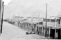
March 18th 1907 was the day known for the great flood. This flood washed out the Thermalito Bridge. The floodwater covered Meyer to Bird St. and all of Montgomery St. The 1907 flood completely destroyed Dredgerville, a small town south of Thermalito. Due to the 1907 flood, a concrete levee was build to protect downtown. |
1937
In December 1937, the Sacramento valley was hit with another flood. The municipal building was built up on stilts to protect it form the raging water. Over fifty families were forced to evacuate.
|
|
1962/1964
When the Oroville dam was being built everyone thought that it would save Oroville from floods, but in October 1962 water torn the Coffer dam. In 1964 the dam site was threatened when waters behind the partially constructed dam built up with nowhere to go but an intake tunnel underneath it.
1986
In February 1986 the releases from the dam covered the operations along highway 70. The river didn't go over the highway, but it seeped through and flooded the east side. |
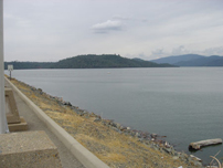
Oroville Dam
In 1951, the California State Legislature authorized the Feather River Project. The project included the Oroville Dam, Reservoir, the power plant, and smaller dams up and down the main dam. The main purpose of the project was to control the floods, irrigation, municipal water supply, and power generation. The watershed that flowed into Oroville Dam had an area of 3,610 square miles. The seasonal run-off of the river at the dam varied from about 4,500,00 acre/feet to 1,200,000 and a maximum of 9,000,000 acre/feet (Soldano).
The dam was located about five miles northeast of Oroville. The first thing that was done after the dam was authorized, was deciding on what kind of dam to build. A mass concrete dam was thought to be the best choice, but after the Oroville Dam Consulting Board was formed in 1956, an embankment type of dam was the decision. Because the dam was an earth-filled dam, the deposit of coarse gravel along the Feather River could be used (Soldano).
On November 1958, it was decided that an embankment dam would be the best decision. This decision was based primarily on financial conditions. The cost of the embankment dam was about 100 million dollars, which was less than the massive concrete dam (Soldano).
The dam had a height of 770 ft and a crest length of 6,800 ft. The dam had approximately 81,000,000 cubic yard to fill. The elevation of the crest was 915 ft above sea level. The surface area of the reservoir was 15,500 acre and it stored about 3,500,000 acre/feet of water (Soldano).
The embankment dam involved many difficult tasks, such as adapting the materials that were available to the structure. Also, adequate allowance was made for earthquakes, since 90% of all earthquakes in the United States occurred in California. The Oroville Dam is literally considered to be earthquake-proof (Soldano). |
|
|